
Rourkela topographic map
Click on the map to display elevation.
Rourkela
Rourkela is located at 84.54E longitude and 22.12N latitude in Sundergarh district of Odisha at an elevation of about 219 m (719 ft) above mean sea level. The area of Rourkela is 200 square kilometers approximately. Being situated on the Howrah-Mumbai rail track, Rourkela had an added advantage of the steel plant being set up there. Red and laterite soils are found here which are quite rich in minerals. The area near Rourkela is rich in iron-ore hence a steel plant is situated in Rourkela. Bolani and Barsuan are the two most prominent mines situated near the town. Rourkela is situated in a hilly region. A small hill range named Durgapur Pahad runs through the heart of the city dividing it into plant area and the steel township. The name "Durgapur" comes from an old village that existed at the foothills long time ago before the plant was set up. The South Koel River and Sankha rivers meet at Vedvyas, Rourkela and flow as a single river called Brahmani.
About this map
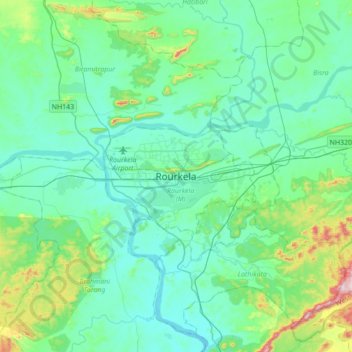
Name: Rourkela topographic map, elevation, terrain.
Location: Rourkela, Raurkela (M), Sundargarh, Odisha, 769002, India (22.07093 84.70787 22.39093 85.02787)
Average elevation: 778 ft
Minimum elevation: 528 ft
Maximum elevation: 1,975 ft