
Thank you for supporting this site ❤️
Make a donation
Make a donation
Gear up for your next adventure:
As an Amazon Associate, this site earns from qualifying purchases at no extra cost to you.
Briccarello topographic map
Click on the map to display elevation.
Thank you for supporting this site ❤️
Make a donation
Make a donation
Gear up for your next adventure:
As an Amazon Associate, this site earns from qualifying purchases at no extra cost to you.
About this map
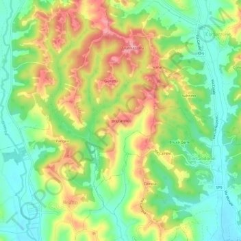
Name: Briccarello topographic map, elevation, terrain.
Location: Briccarello, Cortazzone, Asti, Piemonte, 14014, Italia (44.94520 8.01876 44.98520 8.05876)
Average elevation: 712 ft
Minimum elevation: 545 ft
Maximum elevation: 932 ft
Thank you for supporting this site ❤️
Make a donation
Make a donation
Gear up for your next adventure:
As an Amazon Associate, this site earns from qualifying purchases at no extra cost to you.