
Thank you for supporting this site ❤️
Make a donation
Make a donation
Gear up for your next adventure:
As an Amazon Associate, this site earns from qualifying purchases at no extra cost to you.
Gatún topographic map
Click on the map to display elevation.
Thank you for supporting this site ❤️
Make a donation
Make a donation
Gear up for your next adventure:
As an Amazon Associate, this site earns from qualifying purchases at no extra cost to you.
About this map
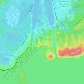
Name: Gatún topographic map, elevation, terrain.
Location: Gatún, Cristóbal, Distrito de Colón, Colón, Panama (9.25067 -79.93823 9.29067 -79.89823)
Average elevation: 72 ft
Minimum elevation: -7 ft
Maximum elevation: 289 ft
Thank you for supporting this site ❤️
Make a donation
Make a donation
Gear up for your next adventure:
As an Amazon Associate, this site earns from qualifying purchases at no extra cost to you.