
Make a donation
Gear up for your next adventure:
As an Amazon Associate, this site earns from qualifying purchases at no extra cost to you.
Morlautern topographic map
Click on the map to display elevation.
Make a donation
Gear up for your next adventure:
As an Amazon Associate, this site earns from qualifying purchases at no extra cost to you.
Morlautern
Morlautern liegt etwa 1,5 km nördlich der Kaiserslauterer Kernstadt. Während der Ortsteil Waschmühle – bekannt durch das gleichnamige Freibad – entlang des Eselsbaches im Tal liegt, befinden sich der Ortskern Morlauterns und der Ortsteil Waldhof auf einer kleinen Hochebene auf einer Höhe von etwa 320 Metern.
Make a donation
Gear up for your next adventure:
As an Amazon Associate, this site earns from qualifying purchases at no extra cost to you.
About this map
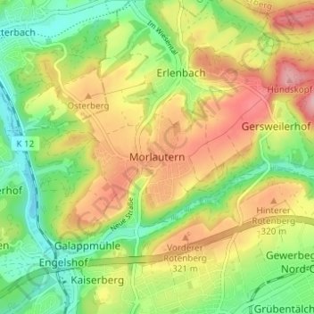
Name: Morlautern topographic map, elevation, terrain.
Location: Morlautern, Kaiserslautern, Rheinland-Pfalz, 67659, Deutschland (49.44996 7.74521 49.48996 7.78521)
Average elevation: 922 ft
Minimum elevation: 702 ft
Maximum elevation: 1,184 ft
Make a donation
Gear up for your next adventure:
As an Amazon Associate, this site earns from qualifying purchases at no extra cost to you.
Other topographic maps
Click on a map to view its topography, its elevation and its terrain.