Geolocate

Lisbon topographic map

Click on the map to display elevation.

About this map

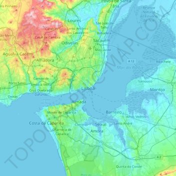
Name: Lisbon topographic map, elevation, terrain.

Location: Lisbon, 1100-148, Portugal (38.54775 -9.29659 38.86775 -8.97659)

Average elevation: 167 ft

Minimum elevation: -10 ft

Maximum elevation: 1,165 ft

Other topographic maps

Click on a map to view its topography, its elevation and its terrain.

São Domingos de Benfica

Portugal > Lisbon > Lisbon

Average elevation: 325 ft

Graça

Portugal > Lisbon > Lisbon

Average elevation: 138 ft

Gear up for your next adventure:

🧷Carabiner Set - Durable clips for gear attachment
🚁Photography Drones - Capture stunning aerial views of landforms and topography
🖼️Topo Map Wall Art - Decorative topographic prints of famous peaks and regions
🔭Compact Binoculars - HD vision for scouting terrain and identifying distant landmarks
🔌USB Car Charger - Car charger for on‑the‑go power needs

As an Amazon Associate, this site earns from qualifying purchases at no extra cost to you.