
Bagnères-de-Luchon topographic map
Interactive map
Click on the map to display elevation.
About this map
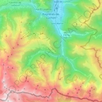
Name: Bagnères-de-Luchon topographic map, elevation, terrain.
Average elevation: 5,476 ft
Minimum elevation: 1,998 ft
Maximum elevation: 10,518 ft
Bagnères-de-Luchon liegt im Tal der Pique, an der Einmündung ihres linken Nebenflusses Neste d’Oô, der hier auch One genannt wird, inmitten der französischen Pyrenäen nahe der spanischen Grenze und dem Val d’Aran in einer Höhe von ca. 630 m. Das Klima ist gemäßigt bis warm; Regen (ca. 875 mm/Jahr) fällt übers Jahr verteilt.
Other topographic maps
Click on a map to view its topography, its elevation and its terrain.
Saint-Pierre
Frankreich > Okzitanien > Haute-Garonne
Saint-Pierre, Toulouse, Haute-Garonne, Okzitanien, Metropolitanes Frankreich, 31590, Frankreich
Average elevation: 577 ft
Toulouse
Frankreich > Okzitanien > Haute-Garonne
Toulouse, Haute-Garonne, Okzitanien, Metropolitanes Frankreich, Frankreich
Average elevation: 509 ft
Luchon-Superbagnères
Frankreich > Okzitanien > Haute-Garonne > Saint-Aventin > Luchon-Superbagnères
Luchon-Superbagnères, Saint-Aventin, Saint-Gaudens, Haute-Garonne, Okzitanien, Metropolitanes Frankreich, 31110, Frankreich
Average elevation: 4,367 ft