
Make a donation
Gear up for your next adventure:
As an Amazon Associate, this site earns from qualifying purchases at no extra cost to you.
Sautron topographic map
Click on the map to display elevation.
Make a donation
Gear up for your next adventure:
As an Amazon Associate, this site earns from qualifying purchases at no extra cost to you.
About this map
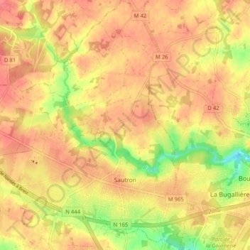
Name: Sautron topographic map, elevation, terrain.
Average elevation: 197 ft
Minimum elevation: 69 ft
Maximum elevation: 256 ft
Make a donation
Gear up for your next adventure:
As an Amazon Associate, this site earns from qualifying purchases at no extra cost to you.
Other topographic maps
Click on a map to view its topography, its elevation and its terrain.
La Trulière
France > Pays de la Loire > Loire-Atlantique > Saint-Mars-de-Coutais
Average elevation: 39 ft
Le Pont Dragon
France > Pays de la Loire > Loire-Atlantique > Saint-Viaud > Saint-Viaud
Average elevation: 62 ft
Make a donation
Gear up for your next adventure:
As an Amazon Associate, this site earns from qualifying purchases at no extra cost to you.
La Possardière
France > Pays de la Loire > Loire-Atlantique > Saint-Étienne-de-Mer-Morte
Average elevation: 69 ft
Le Chemin Noir
France > Pays de la Loire > Loire-Atlantique > Le Loroux-Bottereau
Average elevation: 56 ft
Make a donation
Gear up for your next adventure:
As an Amazon Associate, this site earns from qualifying purchases at no extra cost to you.
Make a donation
Gear up for your next adventure:
As an Amazon Associate, this site earns from qualifying purchases at no extra cost to you.
Balasson
France > Pays de la Loire > Loire-Atlantique > Sainte-Anne-sur-Brivet
Average elevation: 59 ft
Make a donation
Gear up for your next adventure:
As an Amazon Associate, this site earns from qualifying purchases at no extra cost to you.
La Dalonnerie
France > Pays de la Loire > Loire-Atlantique > Saint-Michel-Chef-Chef
Average elevation: 66 ft
Make a donation
Gear up for your next adventure:
As an Amazon Associate, this site earns from qualifying purchases at no extra cost to you.
La Longée
France > Pays de la Loire > Loire-Atlantique > Saint-Philbert-de-Grand-Lieu
Average elevation: 69 ft
Make a donation
Gear up for your next adventure:
As an Amazon Associate, this site earns from qualifying purchases at no extra cost to you.
Les Bertetteries
France > Pays de la Loire > Loire-Atlantique > Saint-Aignan-Grandlieu
Average elevation: 39 ft
La Fontaine Tuaud
France > Pays de la Loire > Loire-Atlantique > Saint-Nazaire
Average elevation: 92 ft
Make a donation
Gear up for your next adventure:
As an Amazon Associate, this site earns from qualifying purchases at no extra cost to you.
Make a donation
Gear up for your next adventure:
As an Amazon Associate, this site earns from qualifying purchases at no extra cost to you.
Les Rochettes
France > Pays de la Loire > Loire-Atlantique > Saint-Julien-de-Vouvantes
Average elevation: 213 ft
La Glénais
France > Pays de la Loire > Loire-Atlantique > Pontchâteau > Saint-Guillaume
Average elevation: 52 ft
Make a donation
Gear up for your next adventure:
As an Amazon Associate, this site earns from qualifying purchases at no extra cost to you.
La Taillée
France > Pays de la Loire > Loire-Atlantique > Montoir-de-Bretagne
Average elevation: 10 ft
Le Petit Haut Bodio
France > Pays de la Loire > Loire-Atlantique > Pontchâteau
Average elevation: 69 ft
Make a donation
Gear up for your next adventure:
As an Amazon Associate, this site earns from qualifying purchases at no extra cost to you.
Saint-Jean-du-Tertre
France > Pays de la Loire > Loire-Atlantique > Vigneux-de-Bretagne
Average elevation: 243 ft
Make a donation
Gear up for your next adventure:
As an Amazon Associate, this site earns from qualifying purchases at no extra cost to you.
Marais de Goulaine
France > Pays de la Loire > Loire-Atlantique > Le Loroux-Bottereau
Average elevation: 36 ft
Bellevue
France > Pays de la Loire > Loire-Atlantique > Sainte-Luce-sur-Loire
Average elevation: 26 ft
Make a donation
Gear up for your next adventure:
As an Amazon Associate, this site earns from qualifying purchases at no extra cost to you.
Le Champ des Mares
France > Pays de la Loire > Loire-Atlantique > Guémené-Penfao
Average elevation: 115 ft
Make a donation
Gear up for your next adventure:
As an Amazon Associate, this site earns from qualifying purchases at no extra cost to you.
La Caillerie
France > Pays de la Loire > Loire-Atlantique > La Haie-Fouassière
Average elevation: 72 ft
La Fontaine aux Bretons
France > Pays de la Loire > Loire-Atlantique > Pornic
Average elevation: 69 ft
Make a donation
Gear up for your next adventure:
As an Amazon Associate, this site earns from qualifying purchases at no extra cost to you.
Make a donation
Gear up for your next adventure:
As an Amazon Associate, this site earns from qualifying purchases at no extra cost to you.
Beaulieu
France > Pays de la Loire > Loire-Atlantique > Vair-sur-Loire > Saint-Herblon
Average elevation: 125 ft
Les Jardins de Blanche-Lande
France > Pays de la Loire > Loire-Atlantique > Oudon
Average elevation: 125 ft
La Grée des Fossés
France > Pays de la Loire > Loire-Atlantique > La Chapelle-des-Marais
Average elevation: 13 ft
Make a donation
Gear up for your next adventure:
As an Amazon Associate, this site earns from qualifying purchases at no extra cost to you.
La Géraudais
France > Pays de la Loire > Loire-Atlantique > La Chapelle-Launay
Average elevation: 144 ft
La Mortière
France > Pays de la Loire > Loire-Atlantique > Saint-Étienne-de-Mer-Morte
Average elevation: 75 ft
Make a donation
Gear up for your next adventure:
As an Amazon Associate, this site earns from qualifying purchases at no extra cost to you.
La Tingère
France > Pays de la Loire > Loire-Atlantique > Pornic > Le Clion-sur-Mer
Average elevation: 46 ft
Make a donation
Gear up for your next adventure:
As an Amazon Associate, this site earns from qualifying purchases at no extra cost to you.
Make a donation
Gear up for your next adventure:
As an Amazon Associate, this site earns from qualifying purchases at no extra cost to you.
Make a donation
Gear up for your next adventure:
As an Amazon Associate, this site earns from qualifying purchases at no extra cost to you.
La Ceriseraie
France > Pays de la Loire > Loire-Atlantique > Le Loroux-Bottereau
Average elevation: 118 ft
Le Moulin Du Pé
France > Pays de la Loire > Loire-Atlantique > Le Loroux-Bottereau
Average elevation: 131 ft
ZAD
France > Pays de la Loire > Loire-Atlantique > Notre-Dame-des-Landes
L'aéroport Nantes Atlantique est situé à un kilomètre au nord du lac de Grand-Lieu – Réseau Natura 2000 (réserve ornithologique et piscicole de l’Ouest de première importance) – et du cœur de Nantes (42 000 personnes concernées par l’actuel PEB). Il est entouré par des zones habitées et…
Average elevation: 200 ft
Make a donation
Gear up for your next adventure:
As an Amazon Associate, this site earns from qualifying purchases at no extra cost to you.
La Hautière
France > Pays de la Loire > Loire-Atlantique > Saint-Fiacre-sur-Maine
Average elevation: 118 ft
Make a donation
Gear up for your next adventure:
As an Amazon Associate, this site earns from qualifying purchases at no extra cost to you.
Le Liminbout
France > Pays de la Loire > Loire-Atlantique > Notre-Dame-des-Landes
Average elevation: 226 ft
La Borgnerie
France > Pays de la Loire > Loire-Atlantique > Saint-Aubin-des-Châteaux
Average elevation: 220 ft
Make a donation
Gear up for your next adventure:
As an Amazon Associate, this site earns from qualifying purchases at no extra cost to you.
Make a donation
Gear up for your next adventure:
As an Amazon Associate, this site earns from qualifying purchases at no extra cost to you.
Le Quennetier
France > Pays de la Loire > Loire-Atlantique > Saint-Lumine-de-Clisson
Average elevation: 148 ft
Make a donation
Gear up for your next adventure:
As an Amazon Associate, this site earns from qualifying purchases at no extra cost to you.