
Thank you for supporting this site ❤️
Make a donation
Make a donation
Gear up for your next adventure:
As an Amazon Associate, this site earns from qualifying purchases at no extra cost to you.
Carrascal topographic map
Click on the map to display elevation.
Thank you for supporting this site ❤️
Make a donation
Make a donation
Gear up for your next adventure:
As an Amazon Associate, this site earns from qualifying purchases at no extra cost to you.
About this map
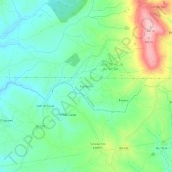
Name: Carrascal topographic map, elevation, terrain.
Location: Carrascal, Sarzedas, Castelo Branco, 6000-708, Portugal (39.81200 -7.72726 39.85200 -7.68726)
Average elevation: 1,024 ft
Minimum elevation: 820 ft
Maximum elevation: 1,463 ft
Thank you for supporting this site ❤️
Make a donation
Make a donation
Gear up for your next adventure:
As an Amazon Associate, this site earns from qualifying purchases at no extra cost to you.