
Hijfte topographic map
Interactive map
Click on the map to display elevation.
About this map
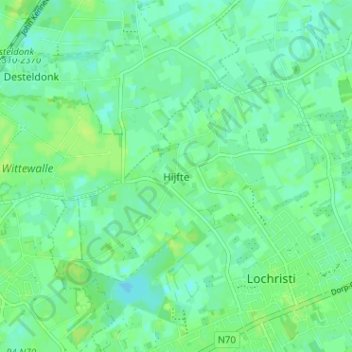
Name: Hijfte topographic map, elevation, terrain.
Average elevation: 20 ft
Minimum elevation: -3 ft
Maximum elevation: 36 ft
Other topographic maps
Click on a map to view its topography, its elevation and its terrain.
Lobos
België > Oost-Vlaanderen > Gent > Lochristi
Lobos, Lochristi, Gent, Oost-Vlaanderen, 9080, België
Average elevation: 20 ft
Lochristi
België > Oost-Vlaanderen > Gent > Lochristi
Lochristi, Gent, Oost-Vlaanderen, 9080, België
Average elevation: 20 ft
Lozen Boer
België > Oost-Vlaanderen > Gent > Lochristi
Lozen Boer, Lochristi, Gent, Oost-Vlaanderen, 9080, België
Average elevation: 16 ft
Beervelde
België > Oost-Vlaanderen > Gent > Lochristi
Beervelde, Lochristi, Gent, Oost-Vlaanderen, België
Average elevation: 20 ft
Zaffelare
België > Oost-Vlaanderen > Gent > Lochristi
Zaffelare, Lochristi, Gent, Oost-Vlaanderen, België
Average elevation: 16 ft
Zeveneken
België > Oost-Vlaanderen > Gent > Lochristi
Zeveneken, Lochristi, Gent, Oost-Vlaanderen, Vlaanderen, België
Average elevation: 16 ft