
Traunwalchen topographic map
Click on the map to display elevation.
Traunwalchen
Traunwalchen liegt an der Traun, einem Nebenfluss der Alz, auf einer Höhe von 556 m ü. NN. Der Ort teilt sich in ein Ober- und Unterdorf sowie die nach 1945 entstandene Siedlung. Neue Baugebiete um die Jahrtausendwende sind die Zachersdorfer Äcker und Frauenbrunn.
About this map
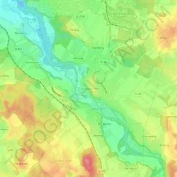
Name: Traunwalchen topographic map, elevation, terrain.
Average elevation: 1,837 ft
Minimum elevation: 1,690 ft
Maximum elevation: 2,011 ft
Other topographic maps
Click on a map to view its topography, its elevation and its terrain.
83371
Deutschland > Bayern > Landkreis Traunstein > Traunreut > Stein an der Traun > Fasanenjäger
Average elevation: 1,739 ft