
Make a donation
Gear up for your next adventure:
As an Amazon Associate, this site earns from qualifying purchases at no extra cost to you.
Arkhyz topographic map
Click on the map to display elevation.
Make a donation
Gear up for your next adventure:
As an Amazon Associate, this site earns from qualifying purchases at no extra cost to you.
Arkhyz
Arkhyz (also Nizhny Arkhyz, Russian: Архыз; Karachay-Balkar: Ырхыз, Irxız lit. 'mudflows') is a village in the valley of the Bolshoy Zelenchuk River, in the Republic of Karachay–Cherkessia, Greater Caucasus, Russia, about 70 km inland from the Black Sea shore. The modern village was founded in 1923 near the confluence of the Arkhyz and Pshish rivers. It is located in a mountainous region in the vicinity of the eponymous aul sitting at an altitude of 1,450 meters. The elevation of the surrounding mountains is more than 3,000 meters above the sea. The population is 505 (2010 Census).
Make a donation
Gear up for your next adventure:
As an Amazon Associate, this site earns from qualifying purchases at no extra cost to you.
About this map
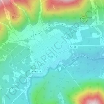
Name: Arkhyz topographic map, elevation, terrain.
Average elevation: 5,935 ft
Minimum elevation: 4,603 ft
Maximum elevation: 9,465 ft
Make a donation
Gear up for your next adventure:
As an Amazon Associate, this site earns from qualifying purchases at no extra cost to you.