
Wörth am Main topographic map
Interactive map
Click on the map to display elevation.
About this map
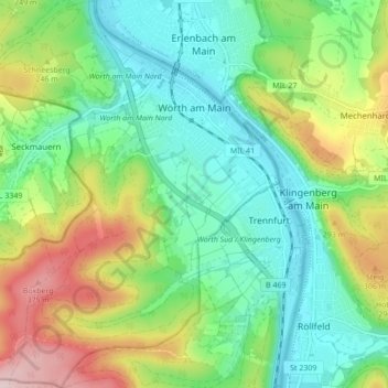
Name: Wörth am Main topographic map, elevation, terrain.
Location: Wörth am Main, Landkreis Miltenberg, Bavaria, 63939, Germany (49.75524 9.10689 49.81091 9.17639)
Average elevation: 692 ft
Minimum elevation: 377 ft
Maximum elevation: 1,329 ft
Other topographic maps
Click on a map to view its topography, its elevation and its terrain.
Bürgstadt
Germany > Bavaria > Landkreis Miltenberg > Bürgstadt
Bürgstadt, Verwaltungsgemeinschaft Erftal, Landkreis Miltenberg, Bavaria, 63927, Germany
Average elevation: 778 ft