
Make a donation
Gear up for your next adventure:
As an Amazon Associate, this site earns from qualifying purchases at no extra cost to you.
Soreq Cave topographic map
Click on the map to display elevation.
Make a donation
Gear up for your next adventure:
As an Amazon Associate, this site earns from qualifying purchases at no extra cost to you.
About this map
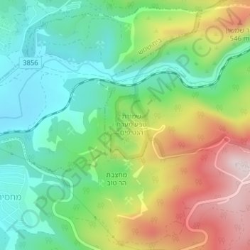
Name: Soreq Cave topographic map, elevation, terrain.
Average elevation: 1,237 ft
Minimum elevation: 709 ft
Maximum elevation: 2,116 ft
Make a donation
Gear up for your next adventure:
As an Amazon Associate, this site earns from qualifying purchases at no extra cost to you.
Other topographic maps
Click on a map to view its topography, its elevation and its terrain.
Maale HaHamisha
Israel > Jerusalem District > Mate Yehuda Regional Council
Average elevation: 2,369 ft
Netiv HaLamed He
Israel > Jerusalem District > Mate Yehuda Regional Council
Average elevation: 1,102 ft
Make a donation
Gear up for your next adventure:
As an Amazon Associate, this site earns from qualifying purchases at no extra cost to you.
Givat Yeshayahu
Israel > Jerusalem District > Mate Yehuda Regional Council
Average elevation: 1,017 ft
Make a donation
Gear up for your next adventure:
As an Amazon Associate, this site earns from qualifying purchases at no extra cost to you.
Make a donation
Gear up for your next adventure:
As an Amazon Associate, this site earns from qualifying purchases at no extra cost to you.