
Quincy topographic map
Click on the map to display elevation.
About this map
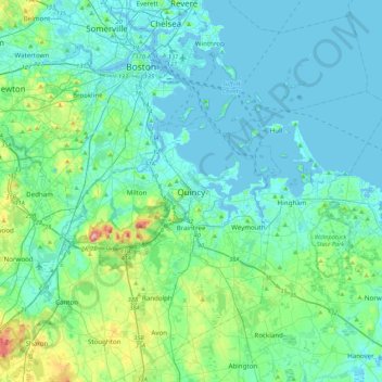
Name: Quincy topographic map, elevation, terrain.
Location: Quincy, Norfolk County, Massachusetts, 02169, United States (42.09099 -71.16374 42.41099 -70.84374)
Average elevation: 92 ft
Minimum elevation: -16 ft
Maximum elevation: 610 ft
Norfolk County trails, hiking, mountain biking, running and outdoor activities
Other topographic maps
Click on a map to view its topography, its elevation and its terrain.
Blue Hills Reservation
United States > Massachusetts > Norfolk County > Quincy
Average elevation: 157 ft