Geolocate

Taverham topographic map

Click on the map to display elevation.

About this map

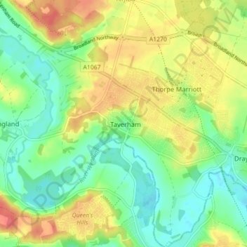
Name: Taverham topographic map, elevation, terrain.

Location: Taverham, Broadland, Norfolk, England, United Kingdom (52.66000 1.16043 52.70269 1.21753)

Average elevation: 82 ft

Minimum elevation: 7 ft

Maximum elevation: 177 ft

Gear up for your next adventure:

🎁Geography Themed Gifts - Unique gift ideas for map lovers and geography enthusiasts
🗺️Topographic Maps - Detailed topo maps for hiking, exploring and outdoor navigation
🛠️Backpacking Tool Kit - Essential toolkit for outdoor repairs
🧣Hiking Neck Gaiter - Multi‑use neck protection for outdoor weather
🚑Emergency Bivvies - Heat-reflective sleeping bags for survival situations

As an Amazon Associate, this site earns from qualifying purchases at no extra cost to you.