
Make a donation
Gear up for your next adventure:
As an Amazon Associate, this site earns from qualifying purchases at no extra cost to you.
Makilo topographic map
Click on the map to display elevation.
Make a donation
Gear up for your next adventure:
As an Amazon Associate, this site earns from qualifying purchases at no extra cost to you.
About this map
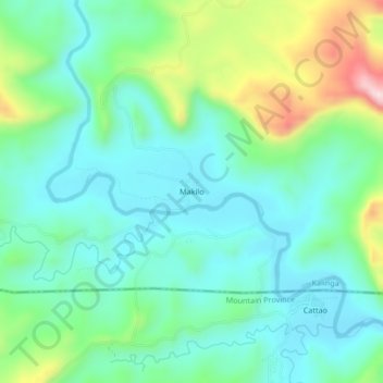
Name: Makilo topographic map, elevation, terrain.
Average elevation: 604 ft
Minimum elevation: 299 ft
Maximum elevation: 1,447 ft
Make a donation
Gear up for your next adventure:
As an Amazon Associate, this site earns from qualifying purchases at no extra cost to you.
Other topographic maps
Click on a map to view its topography, its elevation and its terrain.
Chico River
The Chico River, has a total length of 233 kilometres (145 mi), making it the longest tributary of the Cagayan River, itself the largest river in the Philippines. For centuries it has been central to farming, trading, livelihoods, and daily life, whether as a benefit or hindrance. It provided a source of water…
Average elevation: 1,919 ft
Make a donation
Gear up for your next adventure:
As an Amazon Associate, this site earns from qualifying purchases at no extra cost to you.
Chico River
The Chico River, has a total length of 233 kilometres (145 mi), making it the longest tributary of the Cagayan River, itself the largest river in the Philippines. For centuries it has been central to farming, trading, livelihoods, and daily life, whether as a benefit or hindrance. It provided a source of water…
Average elevation: 1,919 ft