Geolocate

Azle topographic map

Click on the map to display elevation.

About this map

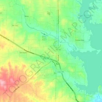
Name: Azle topographic map, elevation, terrain.

Location: Azle, Tarrant County, Texas, 76020, United States (32.86002 -97.59121 32.96028 -97.50872)

Average elevation: 732 ft

Minimum elevation: 581 ft

Maximum elevation: 1,010 ft

Tarrant County trails, hiking, mountain biking, running and outdoor activities

Other topographic maps

Click on a map to view its topography, its elevation and its terrain.

Center Point

United States > Texas > Tarrant County

Average elevation: 719 ft

Azle

United States > Texas > Tarrant County > Azle

Average elevation: 735 ft

Echo Lake Park

United States > Texas > Tarrant County > Fort Worth

Average elevation: 643 ft

Kimzey Park

United States > Texas > Tarrant County > Colleyville

Average elevation: 607 ft

Bob Eden Park

United States > Texas > Tarrant County > Euless

Average elevation: 568 ft

Risk Lake

United States > Texas > Tarrant County > Fort Worth

Average elevation: 568 ft

Fort Worth

United States > Texas > Tarrant County > Fort Worth

Average elevation: 663 ft

Britton Park

United States > Texas > Tarrant County > Mansfield > Britton

Average elevation: 545 ft

Bisbee

United States > Texas > Tarrant County > Mansfield

Average elevation: 699 ft

Boomtown

United States > Texas > Tarrant County > Arlington

Average elevation: 558 ft

Moselle

United States > Texas > Tarrant County > Fort Worth

Average elevation: 764 ft

Winscott

United States > Texas > Tarrant County

Average elevation: 919 ft

Center Point

United States > Texas > Tarrant County

Average elevation: 719 ft

Mansfield

United States > Texas > Tarrant County

Average elevation: 640 ft

Peden

United States > Texas > Tarrant County

Average elevation: 725 ft

Southlake

United States > Texas > Tarrant County > Southlake > Southlake

Average elevation: 623 ft

Rendon

United States > Texas > Tarrant County > Fort Worth

Average elevation: 725 ft

Glenwood Park

United States > Texas > Tarrant County > Fort Worth

Average elevation: 587 ft

Gear up for your next adventure:

🪶Wildlife Field Guides - Learn animal tracking and species ID
🎒Hydration Pack - Hands‑free water reservoir for long hikes
🎒Trekking Poles - Sturdy poles for balance and stability on rough terrain
📦Gear Storage Bags - Organize and protect outdoor equipment
🗺️Topographic Maps - Detailed topo maps for hiking, exploring and outdoor navigation

As an Amazon Associate, this site earns from qualifying purchases at no extra cost to you.