
Make a donation
Gear up for your next adventure:
As an Amazon Associate, this site earns from qualifying purchases at no extra cost to you.
Göschweiler topographic map
Click on the map to display elevation.
Make a donation
Gear up for your next adventure:
As an Amazon Associate, this site earns from qualifying purchases at no extra cost to you.
About this map
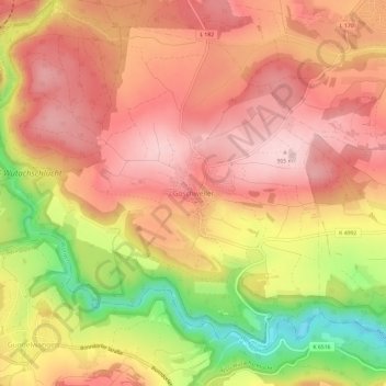
Name: Göschweiler topographic map, elevation, terrain.
Average elevation: 2,664 ft
Minimum elevation: 2,116 ft
Maximum elevation: 2,976 ft
Make a donation
Gear up for your next adventure:
As an Amazon Associate, this site earns from qualifying purchases at no extra cost to you.
Other topographic maps
Click on a map to view its topography, its elevation and its terrain.
Dittishausen
Deutschland > Baden-Württemberg > Landkreis Breisgau-Hochschwarzwald > Löffingen
Average elevation: 2,661 ft
Unadingen
Deutschland > Baden-Württemberg > Landkreis Breisgau-Hochschwarzwald > Löffingen
Average elevation: 2,503 ft
Göschweiler
Deutschland > Baden-Württemberg > Landkreis Breisgau-Hochschwarzwald > Löffingen
Average elevation: 2,667 ft
Reiselfingen
Deutschland > Baden-Württemberg > Landkreis Breisgau-Hochschwarzwald > Löffingen
Average elevation: 2,572 ft
Make a donation
Gear up for your next adventure:
As an Amazon Associate, this site earns from qualifying purchases at no extra cost to you.
Wutachschlucht
Deutschland > Baden-Württemberg > Landkreis Breisgau-Hochschwarzwald > Löffingen
Aus Richtung des Feldbergs bis zur Blumberger Pforte in der Bildmitte quert die Wutach in langer Waldschlucht die offene Südbaar. Ab hier fließt sie nach links durch die Wutachflühen dem Rhein zu, wogegen ihr einstiges Tal, 165 m höher, weiter nach rechts unten zur Donau verläuft.
Average elevation: 2,890 ft