
Make a donation
Gear up for your next adventure:
As an Amazon Associate, this site earns from qualifying purchases at no extra cost to you.
Ambrym topographic map
Click on the map to display elevation.
Make a donation
Gear up for your next adventure:
As an Amazon Associate, this site earns from qualifying purchases at no extra cost to you.
Ambrym
While at higher elevations cinder cones predominate, the western tip of the island is characterized by a series of basaltic tuff rings, of which the largest is about 1 kilometre (0.62 mi) in diameter. These were produced by phreatic eruptions when magma contacted the water table and water-saturated sediments along the coast. The massive, 1900-year-old, 12 kilometres (7.5 mi) × 8 kilometres (5.0 mi) caldera is the site of two active volcanic cones, Benbow and Marum (also spelled Maroum). Mount Benbow was named after English Admiral John Benbow (1653–1702) by Captain Cook.
Make a donation
Gear up for your next adventure:
As an Amazon Associate, this site earns from qualifying purchases at no extra cost to you.
About this map
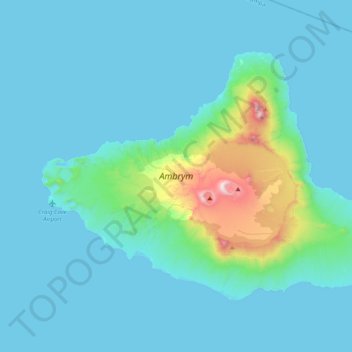
Name: Ambrym topographic map, elevation, terrain.
Location: Ambrym, Malampa, Vanuatu (-16.37119 167.91146 -16.09836 168.31318)
Average elevation: 397 ft
Minimum elevation: 0 ft
Maximum elevation: 3,963 ft
Make a donation
Gear up for your next adventure:
As an Amazon Associate, this site earns from qualifying purchases at no extra cost to you.
Other topographic maps
Click on a map to view its topography, its elevation and its terrain.