
Make a donation
Gear up for your next adventure:
As an Amazon Associate, this site earns from qualifying purchases at no extra cost to you.
Tequixquiac topographic map
Click on the map to display elevation.
Make a donation
Gear up for your next adventure:
As an Amazon Associate, this site earns from qualifying purchases at no extra cost to you.
Tequixquiac
The municipal seat is located in a small, narrow valley, but most of the municipality is on a high mesa between the Valley of Mexico and the Mezquital Valley. The highest mountain in Tequixquiac is the Cerro Mesa Ahumada, with an elevation of 2,600 metres (8,500 ft) above sea level, on the border between the municipalities of Huehuetoca and Apaxco.
Make a donation
Gear up for your next adventure:
As an Amazon Associate, this site earns from qualifying purchases at no extra cost to you.
About this map
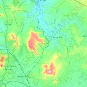
Name: Tequixquiac topographic map, elevation, terrain.
Location: Tequixquiac, State of Mexico, Mexico (19.82282 -99.22776 19.96444 -99.05861)
Average elevation: 7,533 ft
Minimum elevation: 7,110 ft
Maximum elevation: 8,875 ft
Make a donation
Gear up for your next adventure:
As an Amazon Associate, this site earns from qualifying purchases at no extra cost to you.