Geolocate

Lucerne topographic map

Click on the map to display elevation.

About this map
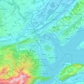
Name: Lucerne topographic map, elevation, terrain.

Location: Lucerne, Switzerland (46.99801 8.20651 47.08352 8.42798)

Average elevation: 2,067 ft

Minimum elevation: 1,345 ft

Maximum elevation: 6,932 ft

Other topographic maps

Click on a map to view its topography, its elevation and its terrain.

St. Erhard

Switzerland > Lucerne > Knutwil

Average elevation: 1,713 ft

Sörenberg

Switzerland > Lucerne

Average elevation: 4,547 ft

Hellbühl

Switzerland > Lucerne

Average elevation: 2,096 ft

Hämikon

Switzerland > Lucerne

Average elevation: 2,201 ft

Allmendhubel

Switzerland > Lucerne > Menznau

Average elevation: 2,087 ft

Alpach

Switzerland > Lucerne > Escholzmatt-Marbach > Escholzmatt

Average elevation: 3,169 ft

Schachen

Switzerland > Lucerne > Werthenstein > Schachen

Average elevation: 2,201 ft

Marbachegg

Switzerland > Lucerne > Escholzmatt-Marbach

Average elevation: 3,802 ft

Schiltalp

Switzerland > Lucerne > Kriens

Average elevation: 3,156 ft

Schloss Meggenhorn

Switzerland > Lucerne > Meggen

Average elevation: 1,476 ft

Gunzwil

Switzerland > Lucerne

Average elevation: 2,201 ft

Gear up for your next adventure:

🌄Hiking Binoculars - Compact binoculars for scenic views and trail spotting
🌲Outdoor Survival Books - Best books on survival skills
👟Trail Running Shoes - Lightweight shoes for trail runners
🪶Compact Camp Shovel - Folding shovel for campsite tasks
🧤Tactile Hiking Gloves - Keep hands warm while operating GPS and smartphone screens

As an Amazon Associate, this site earns from qualifying purchases at no extra cost to you.