
Make a donation
Gear up for your next adventure:
As an Amazon Associate, this site earns from qualifying purchases at no extra cost to you.
Mosqueiros topographic map
Click on the map to display elevation.
Make a donation
Gear up for your next adventure:
As an Amazon Associate, this site earns from qualifying purchases at no extra cost to you.
About this map
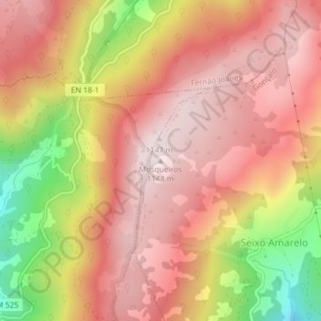
Name: Mosqueiros topographic map, elevation, terrain.
Location: Mosqueiros, Guarda, Centro, Portugal (40.45165 -7.35627 40.45175 -7.35617)
Average elevation: 3,159 ft
Minimum elevation: 2,093 ft
Maximum elevation: 3,740 ft
Make a donation
Gear up for your next adventure:
As an Amazon Associate, this site earns from qualifying purchases at no extra cost to you.
Other topographic maps
Click on a map to view its topography, its elevation and its terrain.
Guarda
A Guarda é a mais alta cidade portuguesa (1056m de altitude), com 26 565 habitantes no seu perímetro urbano, capital do distrito da Guarda, situada na região estatística do Centro e sub-região das Beiras e Serra da Estrela. É sede de um município com 712,1 km² de área e 42 541 habitantes (censos de…
Average elevation: 2,835 ft