
Make a donation
Gear up for your next adventure:
As an Amazon Associate, this site earns from qualifying purchases at no extra cost to you.
Portarró d'Espot topographic map
Click on the map to display elevation.
Make a donation
Gear up for your next adventure:
As an Amazon Associate, this site earns from qualifying purchases at no extra cost to you.
Portarró d'Espot
Le Portarró d'Espot, ou port d'Espot ou col d'Espot en français, est un col de montagne du massif des Encantats dans la chaîne des Pyrénées, situé administrativement dans la province de Lérida en Catalogne, en Espagne. Il se trouve à 2 424 ou 2 427 m d'altitude.
Make a donation
Gear up for your next adventure:
As an Amazon Associate, this site earns from qualifying purchases at no extra cost to you.
About this map
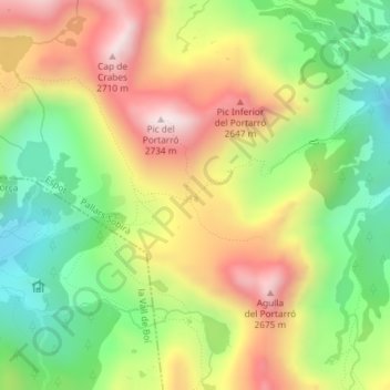
Name: Portarró d'Espot topographic map, elevation, terrain.
Average elevation: 7,641 ft
Minimum elevation: 6,555 ft
Maximum elevation: 8,904 ft
Make a donation
Gear up for your next adventure:
As an Amazon Associate, this site earns from qualifying purchases at no extra cost to you.