
Black Rock Mountain State Park topographic map
Interactive map
Click on the map to display elevation.
About this map
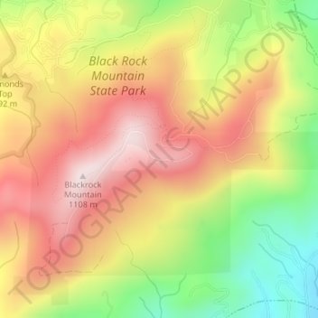
Name: Black Rock Mountain State Park topographic map, elevation, terrain.
Average elevation: 2,851 ft
Minimum elevation: 1,949 ft
Maximum elevation: 3,589 ft
Other topographic maps
Click on a map to view its topography, its elevation and its terrain.
Dillard
United States > Georgia > Rabun County
Dillard, Rabun County, Georgia, United States
Average elevation: 2,267 ft
Tiger
United States > Georgia > Rabun County
Tiger, Rabun County, Georgia, United States
Average elevation: 1,995 ft
Sky Valley
United States > Georgia > Rabun County
Sky Valley, Rabun County, Georgia, 30537, United States
Average elevation: 3,192 ft
Clayton
United States > Georgia > Rabun County > Clayton
Clayton, Rabun County, Georgia, 30525, United States
Average elevation: 2,080 ft