
Make a donation
Gear up for your next adventure:
As an Amazon Associate, this site earns from qualifying purchases at no extra cost to you.
Marechal Cândido Rondon topographic map
Click on the map to display elevation.
Make a donation
Gear up for your next adventure:
As an Amazon Associate, this site earns from qualifying purchases at no extra cost to you.
Marechal Cândido Rondon
A unidade de relevo corresponde ao Terceiro Planalto se apresenta com formas onduladas, aplainadas sendo rebaixadas na direção do Rio Paraná (Lago de Itaipu), em altitudes que variam entre 220 m e 490 m, com média de 420 m na sede municipal.
Make a donation
Gear up for your next adventure:
As an Amazon Associate, this site earns from qualifying purchases at no extra cost to you.
About this map
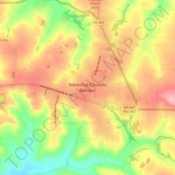
Name: Marechal Cândido Rondon topographic map, elevation, terrain.
Average elevation: 1,250 ft
Minimum elevation: 886 ft
Maximum elevation: 1,581 ft
Make a donation
Gear up for your next adventure:
As an Amazon Associate, this site earns from qualifying purchases at no extra cost to you.