
Make a donation
Gear up for your next adventure:
As an Amazon Associate, this site earns from qualifying purchases at no extra cost to you.
Melun topographic map
Click on the map to display elevation.
Make a donation
Gear up for your next adventure:
As an Amazon Associate, this site earns from qualifying purchases at no extra cost to you.
Melun
La commune est classée en zone de sismicité 1, correspondant à une sismicité très faible. L'altitude varie de 37 mètres à 102 mètres pour le point le plus haut , le centre de la ville se situant à environ 52 mètres d'altitude (hôtel de ville).
Make a donation
Gear up for your next adventure:
As an Amazon Associate, this site earns from qualifying purchases at no extra cost to you.
About this map
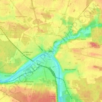
Name: Melun topographic map, elevation, terrain.
Location: Melun, Seine-et-Marne, France métropolitaine, 77000, France (48.49993 2.62082 48.57993 2.70082)
Average elevation: 243 ft
Minimum elevation: 118 ft
Maximum elevation: 348 ft
Make a donation
Gear up for your next adventure:
As an Amazon Associate, this site earns from qualifying purchases at no extra cost to you.