
Thuckalay topographic map
Click on the map to display elevation.
About this map
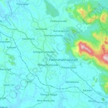
Name: Thuckalay topographic map, elevation, terrain.
Location: Thuckalay, Kalkulam, Kanyakumari District, Tamil Nadu, India (8.19586 77.23568 8.32321 77.39099)
Average elevation: 335 ft
Minimum elevation: 13 ft
Maximum elevation: 3,054 ft
Other topographic maps
Click on a map to view its topography, its elevation and its terrain.
Colachel
India > Tamil Nadu > Kalkulam > Colachel
The town is located on the western coastal side of Kanyakumari District and falls in the coordinates of 8°09′N 77°08′E / 8.15°N 77.14°E / 8.15; 77.14. The average elevation of the town is 25 meters (82 ft) above Mean Sea Level (MSL). Town is mostly characterized by a flat terrain with a few…
Average elevation: 56 ft