Geolocate

Lakeview topographic map

Click on the map to display elevation.

About this map

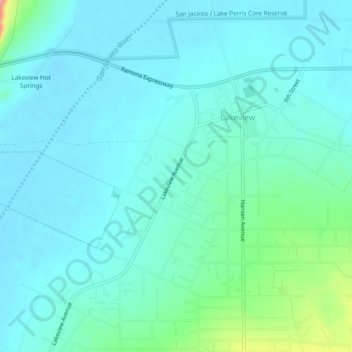
Name: Lakeview topographic map, elevation, terrain.

Location: Lakeview, Riverside County, California, United States (33.81481 -117.14889 33.84046 -117.10113)

Average elevation: 1,480 ft

Minimum elevation: 1,414 ft

Maximum elevation: 1,814 ft

Gear up for your next adventure:

🪄Magnetic Compass - Accurate compass for navigation
🪶Paracord Bracelet - Survival bracelet with built‑in tools
🦺Reflective Outdoor Gear - Safety gear for low‑light conditions
🍳Camping Cook Set - Complete cookware for outdoor meals
🪶Camp Gear Gift Set - Perfect gift bundle for outdoor fans

As an Amazon Associate, this site earns from qualifying purchases at no extra cost to you.