Geolocate

Barobo topographic map

Click on the map to display elevation.

About this map

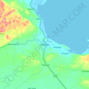
Name: Barobo topographic map, elevation, terrain.

Location: Barobo, Surigao del Sur, Caraga, 8309, Philippines (8.49651 126.08069 8.57651 126.16069)

Average elevation: 141 ft

Minimum elevation: 0 ft

Maximum elevation: 676 ft

Other topographic maps

Click on a map to view its topography, its elevation and its terrain.

Bislig

Philippines > Surigao del Sur

Average elevation: 233 ft

Lingig

Philippines > Surigao del Sur

Average elevation: 230 ft

Lingig

Philippines > Surigao del Sur

Average elevation: 230 ft

Bayabas

Philippines > Surigao del Sur

Average elevation: 115 ft

Bislig

Philippines > Surigao del Sur

Average elevation: 233 ft

Carac-an River

Philippines > Surigao del Sur > Cancavan

Average elevation: 75 ft

Hinatuan

Philippines > Surigao del Sur

Average elevation: 98 ft

Hinatuan

Philippines > Surigao del Sur

Average elevation: 98 ft

Vanishing Island

Philippines > Surigao del Sur

Average elevation: 0 ft

Hinatuan

Philippines > Surigao del Sur

Average elevation: 98 ft

Gear up for your next adventure:

🦶Carbon Trekking Poles - Reduce knee impact on steep descents with ultra-light poles
🎒Waterproof Dry Bags - Keep your electronics and maps dry inside your pack
🧺Microfiber Travel Towels - Compact and fast-drying towels for trail use
🦶Hiking Gaiters - Keep debris and water out of your boots
📷Action Camera - Capture your outdoor adventures in HD

As an Amazon Associate, this site earns from qualifying purchases at no extra cost to you.