
Thank you for supporting this site ❤️
Make a donation
Make a donation
Gear up for your next adventure:
As an Amazon Associate, this site earns from qualifying purchases at no extra cost to you.
Messegães topographic map
Click on the map to display elevation.
Thank you for supporting this site ❤️
Make a donation
Make a donation
Gear up for your next adventure:
As an Amazon Associate, this site earns from qualifying purchases at no extra cost to you.
About this map
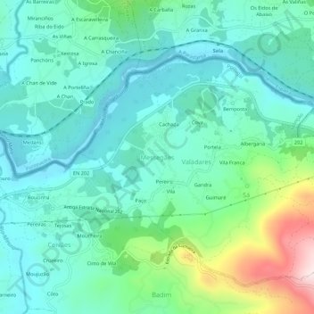
Name: Messegães topographic map, elevation, terrain.
Location: Messegães, Monção, Viana do Castelo, 4950-840, Portugal (42.05762 -8.38640 42.09762 -8.34640)
Average elevation: 381 ft
Minimum elevation: 13 ft
Maximum elevation: 1,614 ft
Thank you for supporting this site ❤️
Make a donation
Make a donation
Gear up for your next adventure:
As an Amazon Associate, this site earns from qualifying purchases at no extra cost to you.