
Make a donation
Gear up for your next adventure:
As an Amazon Associate, this site earns from qualifying purchases at no extra cost to you.
Pervijze topographic map
Click on the map to display elevation.
Make a donation
Gear up for your next adventure:
As an Amazon Associate, this site earns from qualifying purchases at no extra cost to you.
Pervijze
Pervijze ligt in het West-Vlaams poldergebied, en wel in de Middellandpolders, op een hoogte van ongeveer 3 meter. Waterlopen in de directe omgeving zijn: De Grote A-Vaart in het westen, en de Grote Beverdijkvaart in het oosten.
Make a donation
Gear up for your next adventure:
As an Amazon Associate, this site earns from qualifying purchases at no extra cost to you.
About this map
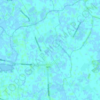
Name: Pervijze topographic map, elevation, terrain.
Location: Pervijze, Diksmuide, West-Vlaanderen, België (51.05764 2.76600 51.10340 2.82645)
Average elevation: 3 ft
Minimum elevation: -7 ft
Maximum elevation: 13 ft
Make a donation
Gear up for your next adventure:
As an Amazon Associate, this site earns from qualifying purchases at no extra cost to you.
Other topographic maps
Click on a map to view its topography, its elevation and its terrain.