
Make a donation
Gear up for your next adventure:
As an Amazon Associate, this site earns from qualifying purchases at no extra cost to you.
Fish Lake topographic map
Click on the map to display elevation.
Make a donation
Gear up for your next adventure:
As an Amazon Associate, this site earns from qualifying purchases at no extra cost to you.
About this map
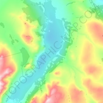
Name: Fish Lake topographic map, elevation, terrain.
Average elevation: 4,311 ft
Minimum elevation: 3,543 ft
Maximum elevation: 5,919 ft
Make a donation
Gear up for your next adventure:
As an Amazon Associate, this site earns from qualifying purchases at no extra cost to you.
Other topographic maps
Click on a map to view its topography, its elevation and its terrain.
Mount Logan
Due to active tectonic uplifting, Mount Logan is still rising in height (approximately 0.35 mm per year). Before 1992, the exact elevation of Mount Logan was unknown and measurements ranged from 5,959 to 6,050 metres (19,551 to 19,849 ft). In May 1992, a GSC expedition climbed Mount Logan and fixed the current…
Average elevation: 17,362 ft
Make a donation
Gear up for your next adventure:
As an Amazon Associate, this site earns from qualifying purchases at no extra cost to you.
Make a donation
Gear up for your next adventure:
As an Amazon Associate, this site earns from qualifying purchases at no extra cost to you.
Make a donation
Gear up for your next adventure:
As an Amazon Associate, this site earns from qualifying purchases at no extra cost to you.
Make a donation
Gear up for your next adventure:
As an Amazon Associate, this site earns from qualifying purchases at no extra cost to you.
Make a donation
Gear up for your next adventure:
As an Amazon Associate, this site earns from qualifying purchases at no extra cost to you.
Make a donation
Gear up for your next adventure:
As an Amazon Associate, this site earns from qualifying purchases at no extra cost to you.
Mount Steele
Mount Steele is the fifth-highest mountain in Canada and either the tenth- or eleventh-highest peak in North America. Its exact elevation is uncertain. Commonly-quoted figures are 5,073 metres (16,644 ft) and 5,020 metres (16,470 ft). A lower southeast peak of Mt. Steele stands at 4,300 m (14,100 ft).
Average elevation: 14,587 ft
Make a donation
Gear up for your next adventure:
As an Amazon Associate, this site earns from qualifying purchases at no extra cost to you.
Make a donation
Gear up for your next adventure:
As an Amazon Associate, this site earns from qualifying purchases at no extra cost to you.
Make a donation
Gear up for your next adventure:
As an Amazon Associate, this site earns from qualifying purchases at no extra cost to you.
Make a donation
Gear up for your next adventure:
As an Amazon Associate, this site earns from qualifying purchases at no extra cost to you.
Mount Logan
Mount Logan (/ˈloʊɡən/ LOH-ghən) is the highest mountain in Canada and the second-highest peak in North America after Denali. The mountain was named after Sir William Edmond Logan, a Canadian geologist and founder of the Geological Survey of Canada (GSC). Mount Logan is located within Kluane National Park…
Average elevation: 17,362 ft
Make a donation
Gear up for your next adventure:
As an Amazon Associate, this site earns from qualifying purchases at no extra cost to you.
Mount Logan
Mount Logan (/ˈloʊɡən/ LOH-ghən) is the highest mountain in Canada and the second-highest peak in North America after Denali (McKinley). The mountain was named after Sir William Edmond Logan, a Canadian geologist and founder of the Geological Survey of Canada (GSC). Mount Logan is located within Kluane…
Average elevation: 17,362 ft
Make a donation
Gear up for your next adventure:
As an Amazon Associate, this site earns from qualifying purchases at no extra cost to you.
Make a donation
Gear up for your next adventure:
As an Amazon Associate, this site earns from qualifying purchases at no extra cost to you.
Make a donation
Gear up for your next adventure:
As an Amazon Associate, this site earns from qualifying purchases at no extra cost to you.
Make a donation
Gear up for your next adventure:
As an Amazon Associate, this site earns from qualifying purchases at no extra cost to you.
Make a donation
Gear up for your next adventure:
As an Amazon Associate, this site earns from qualifying purchases at no extra cost to you.
Mount Logan
Due to active tectonic uplifting, Mount Logan is still rising in height (approximately 0.35 mm per year). Before 1992, the exact elevation of Mount Logan was unknown and measurements ranged from 5,959 to 6,050 metres (19,551 to 19,849 ft). In May 1992, a GSC expedition climbed Mount Logan and fixed the current…
Average elevation: 17,362 ft