Geolocate

Fornaci topographic map

Click on the map to display elevation.

About this map

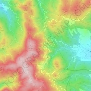
Name: Fornaci topographic map, elevation, terrain.

Location: Fornaci, Sassetta, Livorno, Tuscany, Italy (43.11413 10.62305 43.15413 10.66305)

Average elevation: 1,063 ft

Minimum elevation: 374 ft

Maximum elevation: 1,759 ft

Gear up for your next adventure:

📱Solar Portable Charger - Solar power bank for charging devices off‑grid
👖Convertible Hiking Pants - Versatile zip-off pants for changing altitudes and temperatures
🧣Merino Neck Gaiters - Multi-functional headwear for wind and sun protection
🕶️Glacier Sunglasses - Side shields to protect eyes from high-altitude snow glare
🛰️Satellite Messengers - Emergency SOS and two-way messaging for off-grid adventures

As an Amazon Associate, this site earns from qualifying purchases at no extra cost to you.