
Make a donation
Gear up for your next adventure:
As an Amazon Associate, this site earns from qualifying purchases at no extra cost to you.
Manitoulin Island topographic map
Click on the map to display elevation.
Make a donation
Gear up for your next adventure:
As an Amazon Associate, this site earns from qualifying purchases at no extra cost to you.
About this map
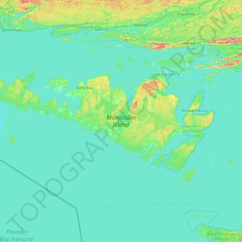
Name: Manitoulin Island topographic map, elevation, terrain.
Average elevation: 636 ft
Minimum elevation: 558 ft
Maximum elevation: 1,545 ft
Make a donation
Gear up for your next adventure:
As an Amazon Associate, this site earns from qualifying purchases at no extra cost to you.
Other topographic maps
Click on a map to view its topography, its elevation and its terrain.
Rabbit Island
Canada > Ontario > Manitoulin District > Northeastern Manitoulin and the Islands
Average elevation: 614 ft
Make a donation
Gear up for your next adventure:
As an Amazon Associate, this site earns from qualifying purchases at no extra cost to you.
Make a donation
Gear up for your next adventure:
As an Amazon Associate, this site earns from qualifying purchases at no extra cost to you.
Herschell Island
Canada > Ontario > Manitoulin District > Cockburn Island Township
Average elevation: 587 ft
Meldrum Bay
Canada > Ontario > Manitoulin District > Unorganized West Manitoulin
Average elevation: 577 ft
Silver Water
Canada > Ontario > Manitoulin District > Unorganized West Manitoulin
Average elevation: 741 ft
Evansville
Canada > Ontario > Manitoulin District > Burpee and Mills Township
Average elevation: 633 ft
Make a donation
Gear up for your next adventure:
As an Amazon Associate, this site earns from qualifying purchases at no extra cost to you.
McKenzie Island
Canada > Ontario > Manitoulin District > Northeastern Manitoulin and the Islands
Average elevation: 689 ft
Little Current
Canada > Ontario > Manitoulin District > Northeastern Manitoulin and the Islands
Average elevation: 633 ft