
Make a donation
Gear up for your next adventure:
As an Amazon Associate, this site earns from qualifying purchases at no extra cost to you.
Pine Hill topographic map
Click on the map to display elevation.
Make a donation
Gear up for your next adventure:
As an Amazon Associate, this site earns from qualifying purchases at no extra cost to you.
About this map
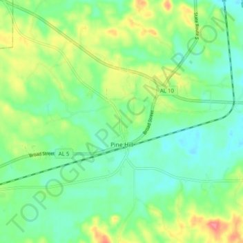
Name: Pine Hill topographic map, elevation, terrain.
Location: Pine Hill, Wilcox County, Alabama, 36769, United States (31.96895 -87.63135 32.00270 -87.55458)
Average elevation: 138 ft
Minimum elevation: 56 ft
Maximum elevation: 295 ft
Wilcox County trails, hiking, mountain biking, running and outdoor activities
Make a donation
Gear up for your next adventure:
As an Amazon Associate, this site earns from qualifying purchases at no extra cost to you.
Other topographic maps
Click on a map to view its topography, its elevation and its terrain.
Yellow Bluff
United States > Alabama > Wilcox County
Its altitude is 31 m above sea level.
Average elevation: 79 ft
Make a donation
Gear up for your next adventure:
As an Amazon Associate, this site earns from qualifying purchases at no extra cost to you.