Geolocate
👉 Easily get elevation data in JSON, GeoTIFF and KML formats using Elevation API
Thank you for supporting this site ❤️
Make a donation

Redding topographic map

Click on the map to display elevation.

Redding

The elevation in Redding is 495 feet (151 meters) on average, whereas anywhere to the north, east, or west of downtown ranges between 550 feet (170 m) and 800 feet (240 m) feet. Southern portions range between 400 feet (120 m) and 500 feet (150 m).

About this map

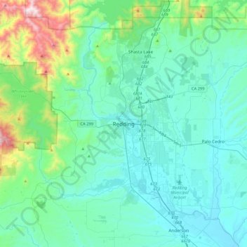
Name: Redding topographic map, elevation, terrain.

Location: Redding, Shasta County, California, 96049-6073, United States (40.42636 -122.55168 40.74636 -122.23168)

Average elevation: 1,024 ft

Minimum elevation: 371 ft

Maximum elevation: 4,593 ft

Shasta County trails, hiking, mountain biking, running and outdoor activities

Gear up for your next adventure:

🪶Trail Camera - Capture wildlife on your hikes
🛶Inflatable Kayak - Portable kayak for rivers, lakes, and expeditions
💧Water Purification System - Clean water on the trail with reliable purifiers
🔦Compact Flashlight - Reliable flashlight for emergencies
🌲Outdoor Survival Books - Best books on survival skills

As an Amazon Associate, this site earns from qualifying purchases at no extra cost to you.