Geolocate

Ladysmith topographic map

Click on the map to display elevation.

About this map

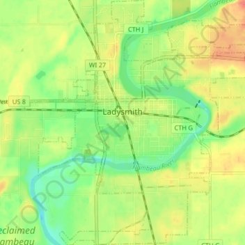
Name: Ladysmith topographic map, elevation, terrain.

Location: Ladysmith, Rusk County, Wisconsin, 54848, United States (45.43763 -91.13065 45.48415 -91.06953)

Average elevation: 1,145 ft

Minimum elevation: 1,070 ft

Maximum elevation: 1,224 ft

Rusk County trails, hiking, mountain biking, running and outdoor activities

Gear up for your next adventure:

🪄Magnetic Compass - Accurate compass for navigation
🧢Outdoor Hiking Hat - Sun protection hat for outdoor explorers
🪶Survival Guide Book - Expert advice for emergency preparedness
🛶Inflatable Kayak - Portable kayak for rivers, lakes, and expeditions
🌎3D Topographic Globes - Raised relief globes for a tactile understanding of geography

As an Amazon Associate, this site earns from qualifying purchases at no extra cost to you.