
Swannanoa topographic map
Click on the map to display elevation.
About this map
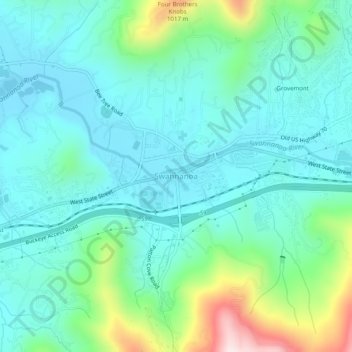
Name: Swannanoa topographic map, elevation, terrain.
Average elevation: 2,474 ft
Minimum elevation: 2,136 ft
Maximum elevation: 3,691 ft
Buncombe County trails, hiking, mountain biking, running and outdoor activities
Other topographic maps
Click on a map to view its topography, its elevation and its terrain.
Asheville
United States > North Carolina > Buncombe County
Asheville, located in Buncombe County, North Carolina, is characterized by a diverse and picturesque topography primarily shaped by its position within the Blue Ridge Mountains. The city itself sits at an elevation of approximately 2,200 feet, surrounded by peaks that rise significantly higher, such as Mount…
Average elevation: 2,385 ft
Asheville
United States > North Carolina > Buncombe County
Asheville has a humid subtropical climate (Köppen Cfa), resembling the rest of the Piedmont region of the southeastern U.S., but with noticeably cooler temperatures due to the higher elevation; it is part of USDA Hardiness zone 7a. The area's summers in particular, though warm, are not as hot as summers in…
Average elevation: 2,385 ft
Haw Creek Park
United States > North Carolina > Buncombe County > Asheville > Dogwood Grove
Average elevation: 2,185 ft
Asheville
United States > North Carolina > Buncombe County
Asheville features a climate that borders between a humid subtropical climate (Köppen: Cfa) and an oceanic climate (Trewartha: Do) with noticeably cooler temperatures than the rest of the Piedmont region of the Southeast due to the higher elevation; it is part of USDA Hardiness zone 7a. The area's summers in…
Average elevation: 2,385 ft
Asheville
United States > North Carolina > Buncombe County
Asheville features a climate that borders between a humid subtropical climate (Köppen Cfa/Trewartha Do) and an oceanic climate (Koppen Cfb) with noticeably cooler temperatures than the rest of the Piedmont region of the Southeast due to the higher elevation; it is part of USDA Hardiness zone 7a. The area's…
Average elevation: 2,385 ft
Asheville
United States > North Carolina > Buncombe County
Asheville features a climate that borders between a humid subtropical climate (Köppen: Cfa) and an oceanic climate (Trewartha: Do) with noticeably cooler temperatures than the rest of the Piedmont region of the Southeast due to the higher elevation; it is part of USDA Hardiness zone 7a. The area's summers in…
Average elevation: 2,385 ft
Asheville
United States > North Carolina > Buncombe County
Asheville features a climate that borders between a humid subtropical climate (Köppen Cfa/Trewartha Do) and an oceanic climate (Koppen Cfb) with noticeably cooler temperatures than the rest of the Piedmont region of the Southeast due to the higher elevation; it is part of USDA Hardiness zone 7a. The area's…
Average elevation: 2,385 ft