
Make a donation
Gear up for your next adventure:
As an Amazon Associate, this site earns from qualifying purchases at no extra cost to you.
Cape Cod topographic map
Click on the map to display elevation.
Make a donation
Gear up for your next adventure:
As an Amazon Associate, this site earns from qualifying purchases at no extra cost to you.
Cape Cod
Cape Cod is a distinctive peninsula characterized by its low, gently sloping terrain that extends 65 miles into the Atlantic Ocean. The landscape consists primarily of sandy soils, dunes, and wetlands, with the highest point at Pine Hill reaching 306 feet. The region is dotted with freshwater ponds and bordered by expansive salt marshes and barrier beaches, which give the area its unique, shifting shoreline. The Cape’s varied topography is heavily influenced by glacial deposits and coastal processes, which shape its irregular and picturesque coastal contours.
Make a donation
Gear up for your next adventure:
As an Amazon Associate, this site earns from qualifying purchases at no extra cost to you.
About this map
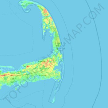
Name: Cape Cod topographic map, elevation, terrain.
Location: Cape Cod, Barnstable County, Massachusetts, United States (41.51497 -70.68798 42.08253 -69.92900)
Average elevation: 7 ft
Minimum elevation: -20 ft
Maximum elevation: 184 ft
Barnstable County trails, hiking, mountain biking, running and outdoor activities
Make a donation
Gear up for your next adventure:
As an Amazon Associate, this site earns from qualifying purchases at no extra cost to you.
Other topographic maps
Click on a map to view its topography, its elevation and its terrain.
Opeechee Heights Beach
United States > Massachusetts > Barnstable County > Barnstable > Centerville
Average elevation: 46 ft
Make a donation
Gear up for your next adventure:
As an Amazon Associate, this site earns from qualifying purchases at no extra cost to you.
Make a donation
Gear up for your next adventure:
As an Amazon Associate, this site earns from qualifying purchases at no extra cost to you.
Make a donation
Gear up for your next adventure:
As an Amazon Associate, this site earns from qualifying purchases at no extra cost to you.
Bourne Corners
United States > Massachusetts > Barnstable County > Bourne > Buzzards Bay
Average elevation: 30 ft
Make a donation
Gear up for your next adventure:
As an Amazon Associate, this site earns from qualifying purchases at no extra cost to you.
Gray Gables
United States > Massachusetts > Barnstable County > Bourne > Buzzards Bay
Average elevation: 16 ft
West Barnstable
United States > Massachusetts > Barnstable County > West Barnstable
Average elevation: 49 ft
Make a donation
Gear up for your next adventure:
As an Amazon Associate, this site earns from qualifying purchases at no extra cost to you.
Make a donation
Gear up for your next adventure:
As an Amazon Associate, this site earns from qualifying purchases at no extra cost to you.
Washburn Island
United States > Massachusetts > Barnstable County > Falmouth > Menauhant
Average elevation: 3 ft
Make a donation
Gear up for your next adventure:
As an Amazon Associate, this site earns from qualifying purchases at no extra cost to you.
Make a donation
Gear up for your next adventure:
As an Amazon Associate, this site earns from qualifying purchases at no extra cost to you.
Campground Landing
United States > Massachusetts > Barnstable County > Eastham
Average elevation: 20 ft
Make a donation
Gear up for your next adventure:
As an Amazon Associate, this site earns from qualifying purchases at no extra cost to you.
Make a donation
Gear up for your next adventure:
As an Amazon Associate, this site earns from qualifying purchases at no extra cost to you.
Barnstable
United States > Massachusetts > Barnstable County > Barnstable > Barnstable
Average elevation: 33 ft
Bournedale
United States > Massachusetts > Barnstable County > Bourne > Bournedale
Average elevation: 95 ft
Dennis Port
United States > Massachusetts > Barnstable County > Dennis > Dennis Port
Average elevation: 10 ft
Make a donation
Gear up for your next adventure:
As an Amazon Associate, this site earns from qualifying purchases at no extra cost to you.