
Thank you for supporting this site ❤️
Make a donation
Make a donation
Gear up for your next adventure:
As an Amazon Associate, this site earns from qualifying purchases at no extra cost to you.
Toacaso topographic map
Click on the map to display elevation.
Thank you for supporting this site ❤️
Make a donation
Make a donation
Gear up for your next adventure:
As an Amazon Associate, this site earns from qualifying purchases at no extra cost to you.
About this map
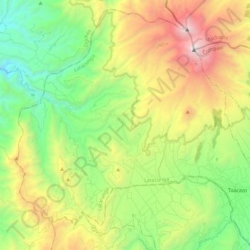
Name: Toacaso topographic map, elevation, terrain.
Location: Toacaso, Latacunga, Cotopaxi, Ecuador (-0.79116 -78.83622 -0.63580 -78.66856)
Average elevation: 11,654 ft
Minimum elevation: 8,376 ft
Maximum elevation: 17,077 ft
Thank you for supporting this site ❤️
Make a donation
Make a donation
Gear up for your next adventure:
As an Amazon Associate, this site earns from qualifying purchases at no extra cost to you.