
Make a donation
Gear up for your next adventure:
As an Amazon Associate, this site earns from qualifying purchases at no extra cost to you.
Anchuruli topographic map
Click on the map to display elevation.
Make a donation
Gear up for your next adventure:
As an Amazon Associate, this site earns from qualifying purchases at no extra cost to you.
About this map
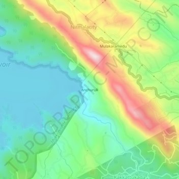
Name: Anchuruli topographic map, elevation, terrain.
Location: Anchuruli, Idukki, Idukki District, Kerala, 685511, India (9.74943 77.05628 9.78943 77.09628)
Average elevation: 2,887 ft
Minimum elevation: 2,336 ft
Maximum elevation: 3,914 ft
Make a donation
Gear up for your next adventure:
As an Amazon Associate, this site earns from qualifying purchases at no extra cost to you.
Other topographic maps
Click on a map to view its topography, its elevation and its terrain.
Shaji A M Ayyamvellil,Kattapana South Kulam
India > Kerala > Idukki > Kattappana
Average elevation: 2,982 ft
Shaji A M Ayyamvellil,Kattapana South Kulam
India > Kerala > Idukki > Kattappana
Average elevation: 2,982 ft
Make a donation
Gear up for your next adventure:
As an Amazon Associate, this site earns from qualifying purchases at no extra cost to you.