Geolocate

Union Furnace topographic map

Click on the map to display elevation.

About this map

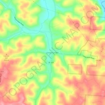
Name: Union Furnace topographic map, elevation, terrain.

Location: Union Furnace, Hocking County, Ohio, 43158, United States (39.44174 -82.37626 39.48174 -82.33626)

Average elevation: 879 ft

Minimum elevation: 676 ft

Maximum elevation: 1,043 ft

Hocking County trails, hiking, mountain biking, running and outdoor activities

Other topographic maps

Click on a map to view its topography, its elevation and its terrain.

Murray City

United States > Ohio > Hocking County

Average elevation: 843 ft

Rose Lake

United States > Ohio > Hocking County

Average elevation: 968 ft

Logan

United States > Ohio > Hocking County

Average elevation: 833 ft

Rose Lake Dam

United States > Ohio > Hocking County

Average elevation: 974 ft

Gear up for your next adventure:

🎒Waterproof Dry Bags - Keep your electronics and maps dry inside your pack
🌄Hiking Binoculars - Compact binoculars for scenic views and trail spotting
🗃️Trail First Aid Kit - Essential kit for outdoor injuries and emergencies
🪶Thermal Camp Blanket - Extra warmth for cold nights
🔥Camping Stove - Portable stove for camping and backcountry cooking

As an Amazon Associate, this site earns from qualifying purchases at no extra cost to you.