
Becks topographic map
Interactive map
Click on the map to display elevation.
About this map
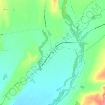
Name: Becks topographic map, elevation, terrain.
Average elevation: 1,289 ft
Minimum elevation: 1,188 ft
Maximum elevation: 1,532 ft
Other topographic maps
Click on a map to view its topography, its elevation and its terrain.
Blue Lake
New Zealand > Otago > Central Otago District > Vincent Community > Saint Bathans
Blue Lake, Saint Bathans, Vincent Community, Central Otago District, Otago, New Zealand
Average elevation: 1,985 ft
Central Otago
New Zealand > Otago > Central Otago District > Vincent Community
Central Otago, Vincent Community, Central Otago District, Otago, 9035, New Zealand
Average elevation: 3,068 ft
Blackstone Hill
New Zealand > Otago > Central Otago District > Vincent Community
Blackstone Hill, Vincent Community, Central Otago District, Otago, 9377, New Zealand
Average elevation: 2,589 ft
Alexandra
New Zealand > Otago > Central Otago District > Vincent Community
Alexandra, Vincent Community, Central Otago District, Otago, 9320, New Zealand
Average elevation: 791 ft
Ophir
New Zealand > Otago > Central Otago District > Vincent Community
Ophir, Vincent Community, Central Otago District, Otago, 9376, New Zealand
Average elevation: 1,109 ft
Clyde
New Zealand > Otago > Central Otago District > Vincent Community
Clyde, Vincent Community, Central Otago District, Otago, 9330, New Zealand
Average elevation: 1,037 ft
Muttontown
New Zealand > Otago > Central Otago District > Vincent Community > Clyde
Muttontown, Clyde, Vincent Community, Central Otago District, Otago, 9391, New Zealand
Average elevation: 679 ft