Geolocate

Baki topographic map

Click on the map to display elevation.

About this map

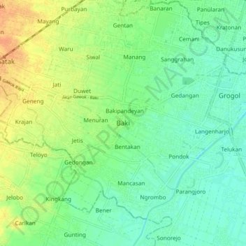
Name: Baki topographic map, elevation, terrain.

Location: Baki, Sukoharjo, Central Java, Java, 57556, Indonesia (-7.65104 110.74367 -7.57104 110.82367)

Average elevation: 328 ft

Minimum elevation: 282 ft

Maximum elevation: 397 ft

Other topographic maps

Click on a map to view its topography, its elevation and its terrain.

Puron

Indonesia > Central Java > Sukoharjo

Average elevation: 420 ft

Bulu

Indonesia > Central Java > Sukoharjo

Average elevation: 413 ft

Lapangan Makamhaji

Indonesia > Central Java > Sukoharjo > Gentan > Kuyudan

Average elevation: 341 ft

Waduk Mulur

Indonesia > Central Java > Sukoharjo > Bendosari

Average elevation: 374 ft

Karangasem

Indonesia > Central Java > Sukoharjo > Karangasem

Average elevation: 377 ft

Gear up for your next adventure:

🦶Carbon Trekking Poles - Reduce knee impact on steep descents with ultra-light poles
🔭Compact Binoculars - HD vision for scouting terrain and identifying distant landmarks
🛠️Outdoor Gear Repair Kit - Essential tools to fix gear on the trail
🪶Trail Camera - Capture wildlife on your hikes
🥾Men's Hiking Boots - Durable, waterproof footwear for rugged terrain and steep inclines

As an Amazon Associate, this site earns from qualifying purchases at no extra cost to you.