
Make a donation
Gear up for your next adventure:
As an Amazon Associate, this site earns from qualifying purchases at no extra cost to you.
Irrhausen topographic map
Click on the map to display elevation.
Make a donation
Gear up for your next adventure:
As an Amazon Associate, this site earns from qualifying purchases at no extra cost to you.
About this map
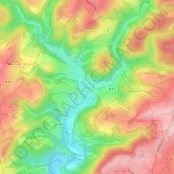
Name: Irrhausen topographic map, elevation, terrain.
Average elevation: 1,453 ft
Minimum elevation: 1,115 ft
Maximum elevation: 1,759 ft
Make a donation
Gear up for your next adventure:
As an Amazon Associate, this site earns from qualifying purchases at no extra cost to you.
Other topographic maps
Click on a map to view its topography, its elevation and its terrain.
Heckhalenfeld
Deutschland > Rheinland-Pfalz > Eifelkreis Bitburg-Prüm > Winterspelt
Average elevation: 1,575 ft
Schweiler
Deutschland > Rheinland-Pfalz > Eifelkreis Bitburg-Prüm > Mützenich
Average elevation: 1,634 ft
Make a donation
Gear up for your next adventure:
As an Amazon Associate, this site earns from qualifying purchases at no extra cost to you.