
Thank you for supporting this site ❤️
Make a donation
Make a donation
Gear up for your next adventure:
As an Amazon Associate, this site earns from qualifying purchases at no extra cost to you.
Buni Yadi topographic map
Click on the map to display elevation.
Thank you for supporting this site ❤️
Make a donation
Make a donation
Gear up for your next adventure:
As an Amazon Associate, this site earns from qualifying purchases at no extra cost to you.
About this map
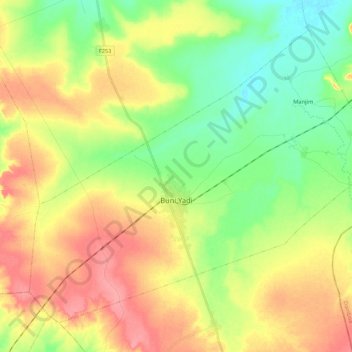
Name: Buni Yadi topographic map, elevation, terrain.
Location: Buni Yadi, Gujba, Yobe, Nigeria (11.20349 11.91884 11.37697 12.13132)
Average elevation: 1,457 ft
Minimum elevation: 1,345 ft
Maximum elevation: 1,585 ft
Thank you for supporting this site ❤️
Make a donation
Make a donation
Gear up for your next adventure:
As an Amazon Associate, this site earns from qualifying purchases at no extra cost to you.