
Make a donation
Gear up for your next adventure:
As an Amazon Associate, this site earns from qualifying purchases at no extra cost to you.
Milburn topographic map
Click on the map to display elevation.
Make a donation
Gear up for your next adventure:
As an Amazon Associate, this site earns from qualifying purchases at no extra cost to you.
Milburn
From an agricultural perspective, however, the Geopark is simply an area of poorly drained grazing that becomes progressively less useful as its altitude increases. Nevertheless, the lower slopes of the inlier are still sufficiently valuable to be enclosed, largely with drystone walling, and are used for grazing sheep and cattle. Fell ponies are also raised here. Immediately above the village, this area is known as Red Carle.
Make a donation
Gear up for your next adventure:
As an Amazon Associate, this site earns from qualifying purchases at no extra cost to you.
About this map
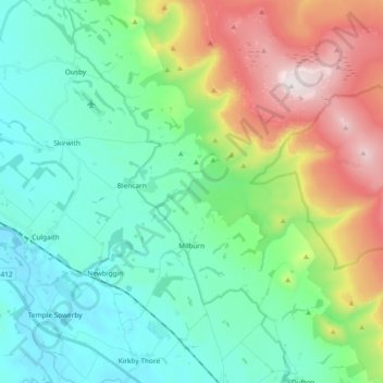
Name: Milburn topographic map, elevation, terrain.
Location: Milburn, Westmorland and Furness, England, United Kingdom (54.63878 -2.55894 54.70728 -2.37259)
Average elevation: 1,050 ft
Minimum elevation: 302 ft
Maximum elevation: 2,930 ft
Make a donation
Gear up for your next adventure:
As an Amazon Associate, this site earns from qualifying purchases at no extra cost to you.
Other topographic maps
Click on a map to view its topography, its elevation and its terrain.
Walney Channel
United Kingdom > England > Westmorland and Furness > Roa Island
Average elevation: 13 ft
Make a donation
Gear up for your next adventure:
As an Amazon Associate, this site earns from qualifying purchases at no extra cost to you.
Pendragon Castle
United Kingdom > England > Westmorland and Furness > Outhgill
Average elevation: 1,132 ft
Kearstwick
United Kingdom > England > Westmorland and Furness > South Lakeland > Kirkby Lonsdale
Average elevation: 312 ft