
Make a donation
Gear up for your next adventure:
As an Amazon Associate, this site earns from qualifying purchases at no extra cost to you.
Sainte-Marie topographic map
Click on the map to display elevation.
Make a donation
Gear up for your next adventure:
As an Amazon Associate, this site earns from qualifying purchases at no extra cost to you.
About this map
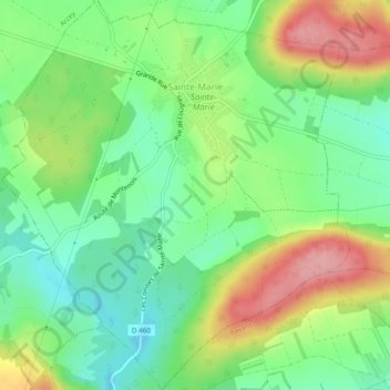
Name: Sainte-Marie topographic map, elevation, terrain.
Average elevation: 1,240 ft
Minimum elevation: 1,076 ft
Maximum elevation: 1,493 ft
Make a donation
Gear up for your next adventure:
As an Amazon Associate, this site earns from qualifying purchases at no extra cost to you.
Other topographic maps
Click on a map to view its topography, its elevation and its terrain.
Mont Châteleu
France > Bourgogne-Franche-Comté > Doubs > Grand'Combe-Châteleu
Average elevation: 3,599 ft
Make a donation
Gear up for your next adventure:
As an Amazon Associate, this site earns from qualifying purchases at no extra cost to you.
Château de Montalembert
France > Bourgogne-Franche-Comté > Doubs > Maîche > Saint-Michel
Average elevation: 2,651 ft
La Corvée de Goux
France > Bourgogne-Franche-Comté > Doubs > Vercel-Villedieu-le-Camp
Average elevation: 2,267 ft
Make a donation
Gear up for your next adventure:
As an Amazon Associate, this site earns from qualifying purchases at no extra cost to you.
Make a donation
Gear up for your next adventure:
As an Amazon Associate, this site earns from qualifying purchases at no extra cost to you.
Make a donation
Gear up for your next adventure:
As an Amazon Associate, this site earns from qualifying purchases at no extra cost to you.
Gouffre du Gros-Bourbier
France > Bourgogne-Franche-Comté > Doubs > Naisey-les-Granges > Granges-de-Vienney
Average elevation: 1,952 ft
Les Granges-l'Église
France > Bourgogne-Franche-Comté > Doubs > Granges-Narboz
Average elevation: 2,946 ft
Lac de Remoray
France > Bourgogne-Franche-Comté > Doubs > Labergement-Sainte-Marie
Le lac de Remoray est situé sur le territoire des communes de Remoray-Boujeons et de Labergement-Sainte-Marie. C'est un lac d'altitude (850 m) en plein cœur des hautes-chaînes du massif du Jura. Il occupe un site de 95 hectares.
Average elevation: 2,910 ft
Make a donation
Gear up for your next adventure:
As an Amazon Associate, this site earns from qualifying purchases at no extra cost to you.
Baume-les-Dames
France > Bourgogne-Franche-Comté > Doubs > Baume-les-Dames
Average elevation: 1,207 ft
Les Pontets
France > Bourgogne-Franche-Comté > Doubs > Les Pontets > Les Pontets
Average elevation: 3,425 ft
Make a donation
Gear up for your next adventure:
As an Amazon Associate, this site earns from qualifying purchases at no extra cost to you.
Châtelblanc
France > Bourgogne-Franche-Comté > Doubs > Châtelblanc > Châtelblanc
Average elevation: 3,451 ft
La Chapelle des Buis
France > Bourgogne-Franche-Comté > Doubs > Besançon
Au Sud de Besançon, au-dessus de la colline Saint-Étienne, une crête rocheuse voisinant les 500 mètres d'altitude s'étend entre Morre et Fontain. Au milieu de cette arête, une légère dépression forme un col entre le vallon des Mercureaux et la pente bisontine. Un second plissement parallèle ferme le…
Average elevation: 1,234 ft
Make a donation
Gear up for your next adventure:
As an Amazon Associate, this site earns from qualifying purchases at no extra cost to you.
Avoudrey
France > Bourgogne-Franche-Comté > Doubs
Avoudrey, village de l'est de la France. Avoudrey est une commune située dans le département du Doubs (ancienne région de Franche-Comté). La commune d'Avoudrey appartient au canton de Valdahon et à l'arrondissement de Pontarlier. Les habitants d'Avoudrey étaient au nombre de 854 au recensement de 2011.…
Average elevation: 2,379 ft
Make a donation
Gear up for your next adventure:
As an Amazon Associate, this site earns from qualifying purchases at no extra cost to you.
Make a donation
Gear up for your next adventure:
As an Amazon Associate, this site earns from qualifying purchases at no extra cost to you.
Make a donation
Gear up for your next adventure:
As an Amazon Associate, this site earns from qualifying purchases at no extra cost to you.
Sur le Mont des Verrières
France > Bourgogne-Franche-Comté > Doubs > Verrières-de-Joux
Average elevation: 3,665 ft
Make a donation
Gear up for your next adventure:
As an Amazon Associate, this site earns from qualifying purchases at no extra cost to you.
Nods
France > Bourgogne-Franche-Comté > Doubs > Les Premiers Sapins
Nods est un village de l'est de la France, situé sur le plateau de Vercel, à 720 mètres d'altitude. On y accède par la RN 57 entre Besançon et Pontarlier.
Average elevation: 2,431 ft
Make a donation
Gear up for your next adventure:
As an Amazon Associate, this site earns from qualifying purchases at no extra cost to you.
Lotissement Le Pralot
France > Bourgogne-Franche-Comté > Doubs > Tarcenay-Foucherans
Average elevation: 1,726 ft
Pont-de-Roide
France > Bourgogne-Franche-Comté > Doubs > Pont-de-Roide-Vermondans
Cette ville est située sur le Doubs et la route départementale 437, à 357 m d'altitude, entre Montbéliard et Morteau.
Average elevation: 1,532 ft
Make a donation
Gear up for your next adventure:
As an Amazon Associate, this site earns from qualifying purchases at no extra cost to you.
Make a donation
Gear up for your next adventure:
As an Amazon Associate, this site earns from qualifying purchases at no extra cost to you.
Fort de Planoise
France > Bourgogne-Franche-Comté > Doubs > Besançon > Aux Valières
Average elevation: 978 ft
Make a donation
Gear up for your next adventure:
As an Amazon Associate, this site earns from qualifying purchases at no extra cost to you.
Make a donation
Gear up for your next adventure:
As an Amazon Associate, this site earns from qualifying purchases at no extra cost to you.
Fort Lachaux
France > Bourgogne-Franche-Comté > Doubs > Sochaux
Il est situé à 410 mètres d'altitude, au sommet d'une colline à la limite des communes de Montbéliard et de Grand-Charmont dans le département français du Doubs.
Average elevation: 1,099 ft
Routelle
France > Bourgogne-Franche-Comté > Doubs > Osselle-Routelle
Le village de Routelle est situé à 220 m d’altitude, à 15 km à vol d’oiseau au sud-ouest de Besançon. À cet endroit, le Doubs franchit une cluse, dernière brèche dans les chaînons du Jura, sa basse vallée s’élargissant progressivement vers Dole et la Saône. L’habitat, relativement…
Average elevation: 843 ft
Make a donation
Gear up for your next adventure:
As an Amazon Associate, this site earns from qualifying purchases at no extra cost to you.
Source de la Loue
France > Bourgogne-Franche-Comté > Doubs > Ouhans
Dans le Jura, les analyses isotopiques et physicochimiques montrent que le chimisme karstique varie dans le temps, au gré des crues et des rythmes de charge et de décharge de la nappe karstique. Et la minéralisation moyenne de sources du Jura varie en outre du simple au quadruple selon qu'elles soient…
Average elevation: 2,162 ft
Make a donation
Gear up for your next adventure:
As an Amazon Associate, this site earns from qualifying purchases at no extra cost to you.
Make a donation
Gear up for your next adventure:
As an Amazon Associate, this site earns from qualifying purchases at no extra cost to you.
Mont Devoir
France > Bourgogne-Franche-Comté > Doubs > Grand'Combe-des-Bois
Average elevation: 3,133 ft
Make a donation
Gear up for your next adventure:
As an Amazon Associate, this site earns from qualifying purchases at no extra cost to you.
Point de vue du Moine
France > Bourgogne-Franche-Comté > Doubs > Mouthier-Haute-Pierre
Average elevation: 2,005 ft
Make a donation
Gear up for your next adventure:
As an Amazon Associate, this site earns from qualifying purchases at no extra cost to you.
Gouffre de Poudrey
France > Bourgogne-Franche-Comté > Doubs > Étalans > Puits de Poudrey
Average elevation: 1,877 ft
Le Mont d'Or
France > Bourgogne-Franche-Comté > Doubs > Longevilles-Mont-d'Or
Le mont d'Or est un sommet du massif du Jura, dans le département du Doubs, en Bourgogne-Franche-Comté, à environ 20 kilomètres au sud de Pontarlier et proche de la frontière suisse. Il s'élève à 1 463 m d'altitude, ce qui en fait le point culminant du département du Doubs. Il a donné son nom à un fromage.
Average elevation: 4,039 ft
Make a donation
Gear up for your next adventure:
As an Amazon Associate, this site earns from qualifying purchases at no extra cost to you.
Éternoz
France > Bourgogne-Franche-Comté > Doubs > Éternoz-Vallée-du-Lison
Average elevation: 1,844 ft
Les Granges d'Agneau
France > Bourgogne-Franche-Comté > Doubs > Verrières-de-Joux
Average elevation: 3,579 ft
Make a donation
Gear up for your next adventure:
As an Amazon Associate, this site earns from qualifying purchases at no extra cost to you.
Chiprey
France > Bourgogne-Franche-Comté > Doubs > Éternoz-Vallée-du-Lison
Average elevation: 1,414 ft
Make a donation
Gear up for your next adventure:
As an Amazon Associate, this site earns from qualifying purchases at no extra cost to you.
Le Beugnon
France > Bourgogne-Franche-Comté > Doubs > Grand'Combe-Châteleu
Average elevation: 2,831 ft
Make a donation
Gear up for your next adventure:
As an Amazon Associate, this site earns from qualifying purchases at no extra cost to you.