Geolocate

San Rafael topographic map

Click on the map to display elevation.

About this map

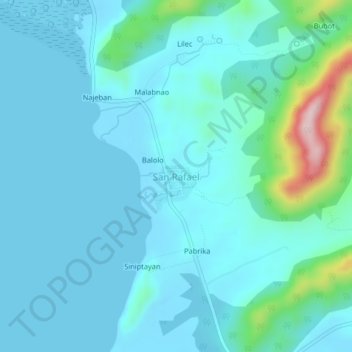
Name: San Rafael topographic map, elevation, terrain.

Location: San Rafael, Busuanga, Palawan, Mimaropa, Philippines (12.16556 119.88844 12.20556 119.92844)

Average elevation: 131 ft

Minimum elevation: -7 ft

Maximum elevation: 978 ft

Other topographic maps

Click on a map to view its topography, its elevation and its terrain.

West Nalaut Island

Philippines > Palawan > Busuanga

Average elevation: 3 ft

Rat Island

Philippines > Palawan > Busuanga

Average elevation: 7 ft

Calauit Safari Park

Philippines > Palawan > Busuanga > Manlag

Average elevation: 23 ft

Horse Island

Philippines > Palawan > Busuanga

Average elevation: 3 ft

Dicilingan Island

Philippines > Palawan > Busuanga

Average elevation: 3 ft

Banaba River

Philippines > Palawan > Busuanga

Average elevation: 184 ft

Gear up for your next adventure:

💧Water Purification System - Clean water on the trail with reliable purifiers
🌲Outdoor Survival Books - Best books on survival skills
🔋Rechargeable Batteries - Power up your outdoor devices
🪓Survival Multi‑Tool - Versatile tool for camp and trail tasks
🔦Compact Flashlight - Reliable flashlight for emergencies

As an Amazon Associate, this site earns from qualifying purchases at no extra cost to you.