Geolocate

Silsbee topographic map

Click on the map to display elevation.

About this map

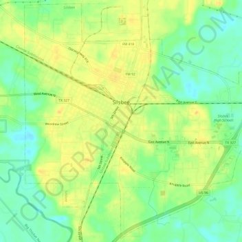
Name: Silsbee topographic map, elevation, terrain.

Location: Silsbee, Hardin County, Texas, United States (30.31971 -94.20248 30.37024 -94.14195)

Average elevation: 66 ft

Minimum elevation: 16 ft

Maximum elevation: 108 ft

Hardin County trails, hiking, mountain biking, running and outdoor activities

Other topographic maps

Click on a map to view its topography, its elevation and its terrain.

Honey Island

United States > Texas > Hardin County

Average elevation: 92 ft

Gear up for your next adventure:

🧣Hiking Neck Gaiter - Multi‑use neck protection for outdoor weather
🚁Photography Drones - Capture stunning aerial views of landforms and topography
👟Men's Trail Runners - Lightweight footwear for fast-paced exploration and light hiking
🗺️NatGeo Topo Maps - High-quality waterproof printed topographic maps of US Parks
🪶Trail Camera - Capture wildlife on your hikes

As an Amazon Associate, this site earns from qualifying purchases at no extra cost to you.